Can anyone help me find a photo of this?
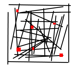
I went to the Museum of Fine Arts Boston the other day and saw this amazing sailing chart once used by the Mauri people of New Zealand. I've drawn a crude schematic.
It's made out of slender flexible twigs that have been tied together in a square lattice. The red squares represent little shells that are tied into the twig lattice.
In use, the twigs represent ocean currents and the shells are islands. Much like the Inuit maps of coastlines that were carved from wood, it floats and you could use it blind if you had to. Amazing.
UPDATE: Yay! Thank you Allison for the "do a Google image search for 'map made of sticks and shells'" suggestion. This is it. It's funny how my memory was of such a more complicated map.
.jpg)
![]()
2 comments:
http://www.advancedaquarist.com/2005/11/lines_album/Shell-Map.JPG
like this?
well, that didn't work out. just emailed you the pic.
Post a Comment